


Results: Syndemic and Geospatial modeling
Published on 06/02/2016
QUESTIONS
GO to COMMENTS
Comments
1.
1.
Check off the terms that you are aware of:
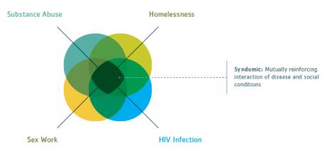
Syndemic: the aggregation of two or more diseases in a population in which there is some level of positive biological interaction that exacerbates the negative health effects of any or all of the diseases.
6%
110 votes
Geospatial: relating to or denoting data that is associated with a particular location
13%
244 votes
Both
9%
169 votes
Neither
73%
1383 votes
2.
2.
If you look at picture #2 you can see a syndemic/geospatial model using data from the Southern California. If you look at the solid red areas, this population only has HIV/AIDS, pretty explanatory. But if you look at the left hand side of the map, you'll find a long green stripe. This stripe starts in Santa Monica and runs to Laguna, basically the LA County beach cities. The populations in these cities have reported only Syphilis. The beach cities are flocked with nightclubs, packed every night. So, as it turns out, patrons from the clubs run out and engage in extracurricular activities that have lead to the spread of Syphilis. I found this new type of mapping/modeling to be acutely fascinating and a way to focus in on who gets what type of health education program. What do you think of syndemic planning and geospatial mapping so far?

Amazing
14%
273 votes
High tech
16%
309 votes
Should help in decreasing sexually transmitted diseases
14%
267 votes
Not sure
31%
594 votes
N/A
32%
612 votes
3.
3.
If you are interested, chances are that the county or the like, that you live in are also using syndemic planning to combat disease. Do you think you'll research to see what diseases lurk in your neck of the woods?

Yes
14%
276 votes
No
29%
546 votes
Undecided
25%
470 votes
Not Applicable
32%
614 votes
COMMENTS